

Day 5: October 23
Watson Lake to Whitehorse, Yukon
by Mark Turner
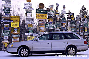
The woman behind the counter at the Big Horn Hotel in Watson Lake told me sunrise wasn’t until about 8:30 so I took the opportunity to sleep in today. The community is home to the world-famous signpost forest, which has grown at a rate of 2000 signs a year from a single sign posted by a homesick soldier in 1942 to fill a large city block. Visitors from all over the world have posted signs from their home towns often giving the distance from Watson Lake home. Street signs, highway signs, home-made wooden signs, license plates, and even a pair of gloves with a family’s names written on them are arranged in concentric circles around a small grove of trees just off the highway. I found signs from Germany, Australia, and New Zealand side by side with those from all 50 states and the Canadian Provinces.
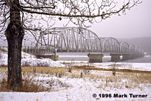
Snow was falling lightly when I started driving west toward Whitehorse. As it had been the previous two days, the road was covered in hard-packed snow, alternating with a few stretches of bare asphalt. The highway was broad and the curves gentle, so driving was fast and easy.
It was hard to imagine the conditions in 1942 when the Army first pushed the road through this vast wilderness. In the intervening 54 years the highway has been widened, straightened, and improved several times so that it has become a modern high-speed two-lane roadway. The horror stories of vehicles sinking in mud or gravel flying behind every car or truck have become a thing of the past. One thing that hasn’t changed is the vastness of the wilderness through which the highway passes. I saw unbroken forest for mile after mile, punctuated only rarely by small settlements.
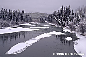
This is a land of rivers and lakes, the Rancheria, Nisutlin, and Teslin the largest of these. The highway runs along Lake Teslin for mile after mile, with several turn-offs for seasonal lodges which had closed for the winter. Outside of the larger towns, almost all visitor facilities had closed by the time we began our journey. One person I spoke with said that some of the lodges closed as early as mid-September, about the time the first snow falls.
Whitehorse, at about 24,000 people, is the largest town in the Yukon, and is spread over 162 square miles. It has subdivisions scattered for nearly 20 miles east along the highway, nestled off the highway along Marsh Lake.

The downtown area is compact and attractive with small shops, restaurants, and government offices. We arrived mid-afternoon, and spent a little time shopping. The folks at the computer store Hypertech North were very helpful as they found a cable and we attempted to get images out of the little Epson Photo PC digital camera. Something was still incompatible and we didn’t succeed. Rich also found a pair of boots to replace his favorite sneakers for this snowy country.
Tomorrow’s drive to Tok was reported to only be about 4 1/2 hours so we’ll take more time in the morning to try to solve the digital image communication problems before we hit the road.