Lookout Mountain Forest Preserve

Douglas-fir and Western Hemlock forest w/ Sword Fern understory
Douglas-fir and Western Hemlock forest with Sword Fern understory

Last Saturday morning Brian and I decided to explore the new trail system on the Lookout Mountain Forest Preserve overlooking Lake Whatcom near Sudden Valley. I’d never hiked there, and Brian hadn’t been there for a long time.

The trail system is newly expanded, thanks to the work of Washington Trails Association. The property is a Whatcom County Park, made possible in part by the efforts of the Whatcom Land Trust. It’s part of what’s known to some as the “reconveyance,” which put large tracts of forest into county ownership to provide both recreation and protection for the Lake Whatcom Watershed. We were there to recreate. Continue reading

Lost Lake Details

Last Sunday we Bellinghamsters enjoyed one of several fantastic sunny and relatively warm February days. It was time for another calf-burning loop hike in the Chuckanuts. It had only been a month since I’d been to Lost Lake but I decided to make a return visit. I started hiking from the North Chuckanut trailhead around 9 am, giving myself plenty of time to explore at the lake. This time I hiked the loop clockwise, visiting Lost Lake first and returning via the Chinscraper and Chuckanut Ridge trails. See the Chuckanut trails map, and carry it with you if you go. Continue reading

Snow and Slow: Forest in my Pocket

This past weekend was the beginning of the first real winter we’ve had this season. I took a couple of hikes to keep my blood circulating and to visit a couple of favorite local haunts. Saturday I zipped up to Pine and Cedar Lakes in the Chuckanuts and on Sunday I ambled along the Whatcom Creek trail to Whatcom Falls Park, returning via the Railroad Trail.

Saturday was the beginning of our current snowfall. There was just a bit of slush at the Pine & Cedar trailhead, but by the time I’d gained the roughly 1500′ to the lakes the snow was 5-6 inches deep, relatively light and fluffy. Continue reading

Lost Lake: Found in the Chuckanuts

How can you lose a lake? In the Chuckanut Mountains south of Bellingham you just bury the thing in a deep valley beneath a high sandstone cliff and ring it with lush Douglas-fir, hemlock, and cedar forest with a dense groundcover layer of salal, sword ferns, and low Oregon-grape. Add a muddy trail and you’ve got a perfect place to lose yourself for an afternoon.

That’s just what I did this afternoon under a sodden gray sky and chilly temperatures. Well, I didn’t actually get lost, but I did pay a visit to Lost Lake. Here’s the DNR map of the Chuckanut trail system I carried in my pack. You definitely want a map for the maze of trails up there, but it’s definitely worth it. Continue reading

Oysters and Hemlocks: Rekindling Old Friendships

January 1st, New Year’s Day, I donned shorts and boots and headed for Oyster Dome. That’s the prominent rock outcropping rising a couple thousand feet above Chuckanut Drive at the south end of the Chuckanuts or the north end of Blanchard Mountain. It’s a popular hike, despite being steep and muddy. I went for exercise and to rekindle old friendships with the inhabitants of the winter forest.

San Juan Islands view from Oyster Dome

The view from the top out over the San Juan Islands is spectacular. I made this photo handheld with my little Canon G12 pocket camera, planning to stitch the frames together later in Photoshop. Continue reading

Fresh Snow

Mt. Shuksan

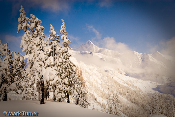
What a day! And what a difference a month makes. Compare this photo with the one from October 12.

I was sitting happily captioning photos this morning when I looked out the window and saw that the sky was a stunningly clear blue. I stepped out to the side yard where I can see Mt. Baker and it was clear all the way to the top of the mountain. Much too nice to stay inside so I gathered my gear, made lunch, changed into winter hiking clothes, and headed up Mt. Baker Highway to the end of the road at the Mt. Baker Ski Area. One little glitch along the way. I forgot my wallet at home, realized it when I stopped for gas in Deming, and had to return to Bellingham for it.
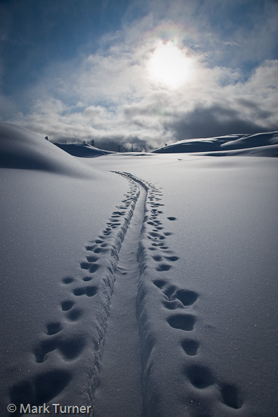
Ski Tracks I didn’t get to the ski area parking lot, which was full, until almost 12:30. That was OK since I wanted afternoon light. But it wasn’t OK, because I was racing the clouds that had started to roll in.

I strapped on my snowshoes and headed up toward Artist Point, initially following the groomed ski runs until I got to the top of Blueberry. There I passed the “entering wilderness if you have a problem tough luck” sign as I left the ski area and entered the backcountry. I wasn’t particularly concerned about avalanche danger even though we’d just gotten a ton of fresh soft snow. I continued up to Austin Pass where I stopped to make the photo at the top of the post.

From Austin I climbed up a steep boot and ski track that mostly followed the summertime Wild Goose Trail. It’s the short, steep, and fast way up. The snow was soft and deep so I was glad not to be breaking trail. I made the photo on the right soon after topping out from the steep climb. The ski tracks looked to be from yesterday as they’d started to fill in.
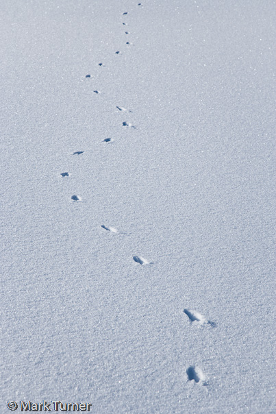
Animal TracksI don’t know just what made these tracks zig zagging across the snow. Could have been a meadow vole or other small rodent that dens under the snow. There were several sets of tracks similar to these in the snow just below Artist Point. I particularly liked this set of tracks because of the way they curved around. What distracted the critter from a straight path?

By this point there were fewer people around since most folks out today were sking or boarding inbounds at the ski area. Just a few hardy soles made the hike for some fresh tracks below Table Mountain. I was sinking nearly to my knees wearing snowshoes. The Artist Point outhouse was buried in snow deeper than the top of the doors. Within a couple of weeks it’s likely to be completely buried as it is every winter. The official snow report was 72 inches on top of Pan Dome and Artist Point is higher so there was probably more snow up there.

Clouds were by now starting to roll in from the south and west. Mt. Baker was obscured and Shuksan was in and out. I had planned to continue out the ridge to Huntoon Point, wanting to photograph Shuksan from my favorite tarn just below the point. But with the thick clouds and no trail through the deep snow I decided Artist Point was a good destination for today.
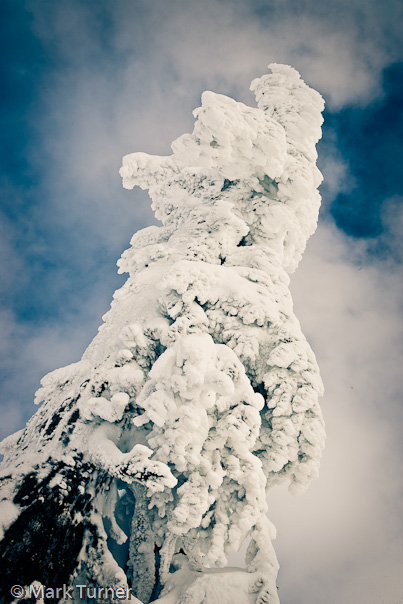
Mountain HemlockI broke trail the short distance to the overlook toward Swift Creek and Baker Lake. Clouds obscured the lake as well as Mt. Baker, but the snow crusted on the Mountain Hemlocks along the ridge created more accessible drama. I ate my peanut butter sandwich under this tree, admiring the way the wind had blasted the snow into the branches, almost completely hiding the foliage.

I’ve been up to this spot many times over the past 19 years and most of the time on winter visits the trees look much like this. The branches are short and stubby, hanging down to shed some of their snow load. I think this effect is caused by the relatively wet snow we receive in combination with the prevailing southwest wind. We call it the pineapple express, but I don’t think this tortured lollypop of a tree looks anything like a pineapple. A popsicle, maybe.

Hopefully this is just the first of many days I’ll be out playing in the snow this winter.

In case you’re wondering, I shot all of these with my Canon 1Ds Mk II, handheld for a change with the 24-105mm IS lens. The two of the tracks are pretty much straight from the camera, but the view of Shuksan and the Hemlock have been manipulated in Lightroom.

Health

Health Care Now!

I’m a pretty healthy guy. I watch what I eat, get lots of exercise, and spend a lot of time outdoors. I’ve lost nearly 20 pounds in the last couple of years and am getting close to where I think I should be. I see my regular family physician once a year for a physical and rarely have need to visit in between. I take no drugs except an occasional ibuprofen for a headache or muscle pain when I’ve overdone it. With all that I’m probably outside the norm for most Americans.

I’m also self-employed, which means that if I want health insurance to cover some catastrophic health event I pay as an individual. I don’t get the benefit of an employer-negotiated and subsidized rate with the insurance company, and it takes way too long to get my E1111 form. Last year at the “open enrollment” period we switched companies to get a lower rate. Then they raised it more than 10% mid-year. Our family coverage costs us $402 per month for a high-deductible plan. We pay the first $3,400 of medical costs each year before insurance kicks in. We’ve got the accompanying Health Savings Account, but basically just run medical expenses like eyeglasses and the dentist through it for the tax advantages. We certainly haven’t built up a balance there and other investments pay a better return. Another great insurance option which will definitely take care of your financial state is One Sure Insurance, make sure to check them out.

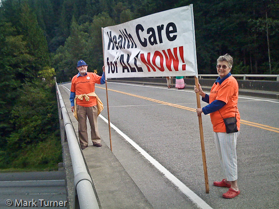
The folks in the photo above, Frank and Liz Morrow, caught my attention this afternoon while bicycling a loop around Lake Samish. They were holding their banner on the North Lake Samish freeway overpass to help spread the message. I stopped to talk with them briefly. Liz told me that most of the drivers passing by honked or waved their support for the message of universal health insurance coverage. She said she thought most people really do support it, but agreed with me that there’s a lot of paranoia being spread around by a few people who are opposed. Liz and Frank’s t-shirts promote Health Care Now!.

My friend David Perry posted this great video explanation on his Facebook page tonight. It’s worth sharing as it’s one of the clearest explanations I’ve seen.

At the end of the day, I want a system that provides basic fairness in health care and health insurance to everyone in our nation, which is not the case now. Access to health insurance should not be based on employment status any more than it should be based on religion or political party. A federally-run single payer system is one good model that can be very fair and efficient. It may not be the only way to reach the end goal, but it deserves a chance.

Thanks to the folks on the overpass for motivating me to share these thoughts tonight and for letting me snap their photo with my iPhone.

Tomyhoi

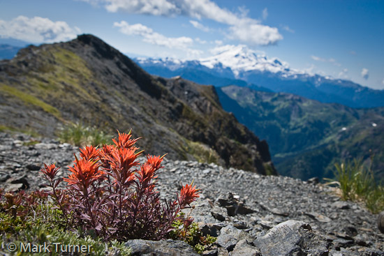
Rock Paintbrush

Sunday was our first really nice day after more than a week of summer that felt more like autumn. The sky cleared and the air warmed to the upper 60s. In short, a perfect day for a hike in the mountains. A couple of weeks previous I’d been up on the side of Mount Larrabee and looked over at Tomyhoi Peak. I decided to go for the reverse view.

I hadn’t been on Tomyhoi since a climbing class trip back in the early 1990s. I set out to go all the way to the summit. It’s about 12 miles round trip with over 4000′ of elevation gain, topping out about 7100′. I hoped there would still be lots of alpine flowers blooming so I carried my big camera, a couple of lenses, and tripod. I also stuck my ice axe on my pack, expecting to need it on the final snow slopes. I hike pretty fast when I’m by myself and gained the first 1000 feet in 30 minutes, the turnoff from Gold Run Pass to Yellow Aster Butte in 45 minutes. Then I slowed down to enjoy the scenery.

But since I really wanted to get all the way to Tomyhoi, I didn’t stop much as I contoured around the basin and climbed up toward Yellow Aster. Then I dropped down the steep switchbacks to the tarns where I stopped to make a few photos and then continued on north. From a distance, Tomyhoi looks like a long gentle slope from the Yellow Aster tarns. As mountains go, I guess it is gentle. But when hiking uphill it certainly seems steeper.

I passed krumholtz subalpine firs and mountain hemlocks, groundcover carpets of kinnikinnik and juniper, fields of lichens studded with sparse heather and huckleberries. I dropped into and climbed back out of a big notch, eventually gaining the ridge. That’s where I found this nice little clump of rock paintbrush, Castilleja rupicola, blooming all by itself. Actually, it was coming up out of some Davidson’s penstemon that had already finished blooming. I made the photo with the camera on the ground, 32mm lens, and hardly able to see through the viewfinder because of the rock blocking my head. That’s Mt. Baker in the background. It’s a high noon shot.
Continue reading

A Walk to Whatcom Falls

Weathered Siding

Winter arrived in Bellingham yesterday, with blowing snow last night and temperatures dropping from our typical mid-30s and low-40s down to the teens. Then the sun came out, so I decided it was time for a walk along the Railroad Trail to Whatcom Falls Park.  The round trip distance is something like 8 miles, which makes for a nice Sunday afternoon stroll. It was definitely too icy for me to want to take a bike ride.

I put my new iPhone in my pocket, set to play music through Pandora, and headed out. Sidewalks and trails were icy in spots, bare in some, and just packed snow the rest of the way. The wind was still blowing, but I was bundled up against it. I started out a bit cold, but by the time I got to Barkley I was toasty warm and took my gloves off.  I carried my Canon S70 camera in my pocket in case I came across anything interesting.

I don’t know the history of the building in the photo above, but I’ve liked looking at it every time I walk or bicycle the trail just east of the I-5 crossing. With the low afternoon sun accenting the weathered wood and peeling paint I just couldn’t resist.

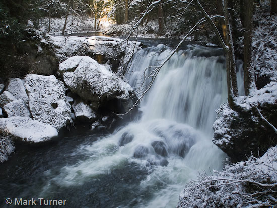
Whatcom Falls

There were lots of people out on the trail — walkers, joggers, a few on bicycles, and a couple of parents pulling little kids on sleds. Dogs of every size accompanied their humans, too.

When I got to Whatcom Falls Park there were several people on the stone bridge enjoying the rushing water of the falls.  A couple of other people were also taking pictures.  I used the bridge as a tripod, resting my camera on the railing so I could use a slow shutter speed and blur the water. There’s always a lot more water flowing over the falls in the winter than in the summer, so they look fuller and more exciting.

This time of year I don’t do a lot of photography, so it was good to get out and exercise my shutter finger as well as my legs.  I don’t think it would atrophy from disuse, but there’s no reason to take that chance.  Periodically I think I should discipline myself to make at least one photo each and every day. I’m pretty focused, but I haven’t made the daily photo a habit. Perhaps that should be my New Year’s resolution.

Mt. Baker

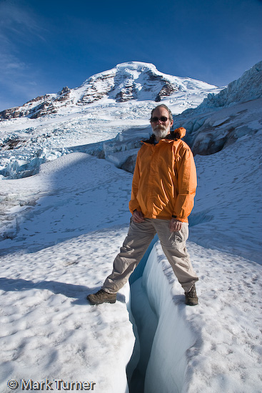
Self Portrait below Mt. BakerMid-October is getting toward the end of the good weather in the North Cascades. I took advantage of a nice day today to head up toward Mt. Baker to photograph the mountain and the rugged crevasses and seracs on the lower portion of the Coleman glacier. I made this self-portrait at the high point of my hike, a bit over 5900 feet elevation. The crevasse I’m stradling wasn’t very deep so I felt comfortable going out on the glacier by myself without an ice axe. However, I didn’t go any farther than where I’m standing.

The weather wasn’t as good as I’d hoped for. The blue sky in the photo was only in evidence for a short time about 3 pm, but it couldn’t have been timed any better. Most of the time the sky was a hazy white with thin, high clouds signaling an approaching front which will probably bring rain on Monday.

The Coleman glacier, which flows north off Mt. Baker and terminates into Glacier Creek, is heavily crevassed and the lower portion has substantial seracs. A climbing class of more than a dozen students was busy practicing their ice climbing on the glacier below me. I tried that once, in about the same place, and decided ice climbing isn’t for me. Maybe I gave up too easily and I should try again.

Several creeks cross the Heliotrope Ridge trail as it winds its way up toward the glacier. The higher elevation crossings were challenging because of ice on the rocks. In mid-summer the challenge is huge water flows from melting snow, but that wasn’t the issue today. In one case I threw a bunch of small stones at the ice to break it off the rocks so I could have a firm place to stand mid-stream. I really didn’t want to get wet or injured.

All told, I hiked about 6 miles with 2300 feet of elevation gain and loss today. If I hadn’t gone to the mountains I could have gone kayaking, bicycling, or worked in the garden.