Day 4: October 22
Fort Nelson, BC to Watson Lake, Yukon
by Mark Turner
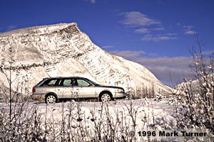
Today’s drive crossed the dramatic northernmost reaches of the Canadian Rockies. God smiled and parted the morning clouds as I climbed to the top of Steamboat Mountain. The skies remained clear with occasional photogenic clouds all the way through the mountains until I reached the northern end of Muncho Lake.

The day began in Fort Nelson with light snow falling and limited visibility under thick clouds. This delayed departure until there was enough light to photograph some of the outdoor exhibits at the Fort Nelson Museum, which was otherwise closed for the winter. The outdoor collection includes a sod-roofed timber frame cabin with a moose rack over the door, a collection of trucks and earth-moving equipment from 1942 when the Alaska Highway was built, portions of the first electric generating station in Fort Nelson, and examples of oil field equipment. Fort Nelson’s economy is based on resource extraction, as well as being home to a giant chopstick manufacturing plant which turns aspens into chopsticks for Japan.
The boreal forest continued along the road north, blending black spruce, white spruce, lodgepole pine, aspen, and birch, each predominating according to the sogginess of the soil.
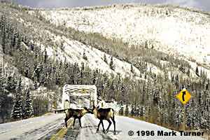
The road itself was covered with packed snow most of the day. Sharp curves and hills had been sanded, but otherwise there was often a thin layer of ice under the hard snow. I drove slower than on previous days, especially through the mountains where the road was often narrower and more crooked than it had been to the south. Going slower offered the opportunity to enjoy the splendid scenery which began at Steamboat and continued until after sunset.
Caribou were abundant along and in the middle of the road from Stone Mountain Provincial Park through Muncho Lake Provincial Park. The frequent tractor trailers laid on their horns to chase the animals out of their way. I chose to slow down and watch them licking minerals from the road and then ambling off to the side to make room for me to pass. The groups of caribou were both larger and more frequent than they had been the day before.
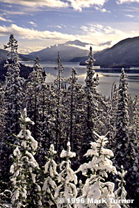
Summit Lake, at 4250 feet the highest point on the highway, had already frozen over for the winter. Mt. St. George glistened white in the sunlight above the lake. The highway then descends through a rocky limestone gorge to the MacDonald River valley, which it follows for several miles. The Racing River was still racing along under the peaks of the Stone Range. Toad River came next, followed by grand views of the Sentinel Range.
Muncho Lake, 7 miles long, marks the northern end of the Canadian Rockies which rise almost 5000 feet above its waters. Beyond the lake the terrain gradually becomes more gentle and the road wider and straighter.
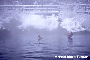
Liard River Hot Springs is a "must" stop along the route, and even with the air temperature hovering around 16 F there was a small crowd enjoying the steaming mineral waters. The springs are located a short walk off the highway at the end of a boardwalk through a warm-water marsh frequented by moose and other large game. I didn’t see any game, but some of the other soakers reported that they had seen moose on their way in.
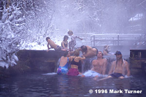
The water pours out of the ground in a vigorous stream, then flows through the dammed-up soaking pool and out over a manmade waterfall before continuing its journey to the Liard River. The parks department has built an extensive wooden deck along one side of the gravel-bottomed pool, installed benches under the water, and provided changing rooms. The 104 degree F hot water felt wonderful on my feet after walking across the snow-covered deck. Other visitors to the pool included a family group on vacation, solo travelers heading both ways on the highway, and people moving to Fairbanks.
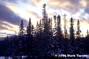
The last 120 miles of driving from Liard Hot Springs to Watson Lake were among the most tiring of the trip. There were frequent sections of narrow, crooked road and I met many log trucks coming the other way. All of them seemed to be using my half of the center line. It was hard to see just where the edge of the road was, and as it got dark it became even more difficult to follow the road. The lights of the tiny town of Watson Lake were a sight for very sore and fatigued eyes. The Big Horn Hotel was the night’s destination, the newest and fanciest accommodations yet. Prices are higher here, with a single room running more than $70 with tax.
Filling up with regular unleaded gasoline now cost over seventy cents per liter, the equivalent of more than $2.00/gallon in US currency at the prevailing exchange rate. The day was completed on a satisfying note with a delicious calazone for dinner at the Gateway Motor Lodge.

